Proof of construction date
When was the building built – from aerial photos and the building register
How an unauthorised building is entered in the register depends on when it was built, and the owner must provide evidence of the construction date. We review the Land and Spatial Board’s aerial photos and the building register documents and write in a report what they show about your building.
- Price
- €85.56 (€69 + VAT) per building
- Turnaround
- usually one working day
- Result
- PDF report by e-mail
- Sources
- Land and Spatial Board, building register
Why the construction date matters
The law divides unauthorised buildings into groups by construction date. Each group has its own procedure. Without sufficient evidence of the construction date, the building is presumed to have been built after 1 January 2003.
- Before 22.07.1995
- If the land is in the land register, a legal basis for construction is presumed. The building is usually entered in the register with a data submission notice. Later extensions and alterations are assessed separately, and the building must be safe.
- Before 1.07.2015
- If the building is complete and no longer needs works requiring a building notice or building permit, it can be entered in the register with a notice of use or a permit of use – without a building notice or building permit. If there is no building design, a building audit replaces it.
- Later
- The general procedure of the Building Code applies: where required a building design and a building notice or building permit, then a notice of use or permit of use.
Basis: § 27(3) and § 28 of the Building Code and Planning Act Implementation Act (version in force from 1.08.2026). The owner provides evidence of the construction date; the municipality establishes the facts and assesses the evidence (Administrative Procedure Act § 6 and § 38).
How we determine the construction date
Building outline from the register
We find the building in the building register and take its outline.
All available aerial photos
We draw the outline on the Land and Spatial Board’s aerial photos (orthophotos) from the 1990s onwards and note what each photo shows and when it was taken.
Comparison with documents
We compare the photos with the building register documents (permits, notices, energy certificates) and the Google Street View capture dates.
Conclusion
We state between which two photos the building or extension appeared and what this shows in relation to the dates set in law.
Example: Estonian National Museum, Tartu
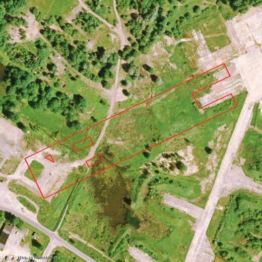
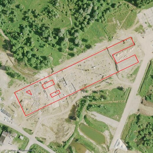
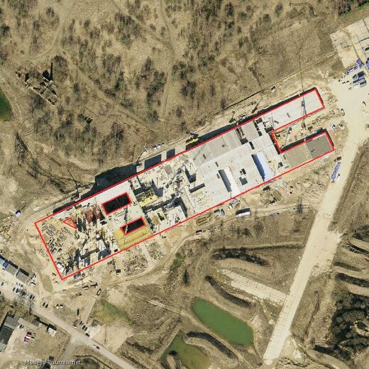
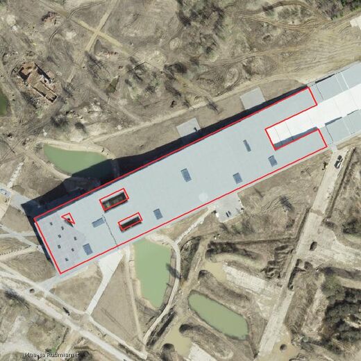
The red line shows the building outline from the building register. Aerial photos: Land and Spatial Board (open data licence).
What the report contains
Conclusion first
For example: “The extension is visible on the 2009 aerial photo, so it was built before 1 July 2015.”
Aerial photos by year
The available years, the building outline on each photo, the capture date and a note on what the photo shows.
Building register data and documents
With dates: permits, notices, energy certificates.
One timeline
Photos and documents side by side.
Next steps
Which document to submit to the municipality and what to attach.
When the report does not help
Changes inside the building
Walls, building services or flat alterations are not visible on aerial photos.
Building under trees or in shadow
The outline may then not be visible on the photo.
Dates before the 1990s
Archive documents are then needed; we tell you in advance whether this is possible and what it costs.
The report describes what the photos and documents show. It does not enter the building in the register, and the municipality makes the decision. We can handle the register entry for you – the report is then included in its price.
Price and terms
- One building
- €85.56 (€69 + VAT)
- Additional building
- each further building on the same property €35.96 (€29 + VAT)
- Turnaround
- usually one working day after the order is confirmed
- With legalisation
- if you also order the register entry from us, the report is included in its price
- For estate agents
- can be ordered on behalf of the seller or buyer, invoice to a company possible
Questions
Does the municipality accept aerial photos as evidence?
The law does not specify which evidence must be used to show when a building was built. In administrative proceedings a document such as an aerial photo can be evidence (Administrative Procedure Act § 38(2)). The municipality assesses the evidence. The more sources support each other – photos, register documents, invoices, the owner’s own photos – the stronger the evidence.
Can I look at the aerial photos myself?
Yes. The Land and Spatial Board’s historical aerial photos are free for everyone in its map application. Our work is to find the right years and capture dates, draw the building outline from the building register on the photos, compare them with the register documents and write a conclusion you can attach to the notice submitted to the municipality.
The house is old, but the sauna and shed were built later. Will the report help?
It helps most with buildings added later – a sauna, shed or extension – to show whether they were built before 1 July 2015. If the date before 22 July 1995 must be shown, we also use 1990s aerial photos and archive documents. Before you order, we tell you whether this is possible in your case.
Do you use Google Street View?
Yes, if the building is visible from the street. Street View has been captured in Estonia since 2011. We record the capture date shown by Google (month and year) and a link in the report; we do not copy Google’s images.
Ask before ordering
Write the address and which building or extension needs its construction date shown. We check free of charge whether aerial photos can help in your case. If they can, we agree on the order by e-mail.

Reports are prepared and enquiries answered by Marko Toomik
Seadusta.ee · Normrise OÜ
An enquiry does not oblige you to order. We use your data to answer the enquiry (see the privacy notice).